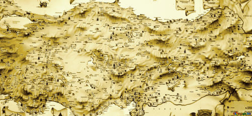
As it is known, the geographical position of Anatolia is a bridge that connects two continents, Europe and Asia. It has been a frequent destination an home for various civilizations throughout history. Nevertheless, Anatolia is not only a bridge but also a place that has been crossed over again and again. Turkey’s Geography and Climate have affected human life and therefore the entire economic life of the region in every era. This is more effective in ancient times than today because a human could reduce these natural effects less day by day. We see the best example of this in transportation.
In the earliest times, while goods or goods were transported through natural roads with cargo animals, today land transport is carried out via trains and motor vehicles, through custom-made viaducts and tunnels. When we look at the geography of Anatolia, we see the mountain ranges that run parallel to the Black Sea in the north. We can list the most important of these mountains from west to east as follows: Bolu Mountains, Küre Mountains, Ilgaz Mountains, Köroğlu Mountains, Canik Mountains, and Eastern Black Sea Mountains. Likewise, the Taurus Mountains are located in the south, parallel to the Mediterranean. Thus, the inner part of Anatolia has been separated from the north and south and has become a difficult region to reach.

Apart from the coastal region, Anatolia has a climate dominated by weather conditions which are often harsh in winter depending on these landforms. However, it is useful to state that; In ancient times, forest land should have covered a much larger area in the Central Anatolia Region. Both in the Hittites Period and in Antiquity and Ottoman periods; We need to think that wood was cut extensively due to needs such as tool making, heating, and home construction.
Especially in the Hittites period, tree cutting in Central Anatolia reached its peak. Because the center and capital of the Hittite State were also located in Central Anatolia. As for the Aegean coast, the contact between the coast and Central Anatolia is relatively easier, as the mountains lie perpendicular to the sea. If we count the most important mountains of Western Anatolia from north to south: Kaz Mountain, Madra Mountain, Boz Mountains, Aydın Mountains, and Menteşe Mountains. Looking at Southeast Anatolia, it is possible to say that the south of the Southeast Taurus took a very different shape. Southeast Taurus Mountains are literally a barricade with altitudes exceeding 2000 in most places.
It is worth noting that the temperature difference between summer and winter is extremely high. The region gets higher towards the east and its climate gets harder. While the average altitude of the Şanlıurfa and Mardin Plateaus and the Diyarbakır Basin is below 1000 m, it passes even 2000 meters in the further east and even approaches 3000 meters. It is known that Turkey’s mountains in Eastern Anatolia are higher than those we have already counted. Turkey’s height increases from west to east in general. The altitude in the east does not usually go below 1000 meters, even above 1500 meters. The mountains are generally over 3000 meters and the highest summit is Mount Ararat (5137m). Mount Ararat with its great height and majestic shape, has been the center of many legends. This is the famous mountain where the ark of Noah anchored after the flood. I hope you will have a chance to see Ararat mountain once in your life.
You can contact me to learn more about Turkey’s geography and book tours around Turkey. See you soon, Hasan Gülday.